M and J have been keeping track of how many states they've ever visited and were debating whether or not to count Nebraska (slept through it overnight on the Amtrak California Zephyr) and Texas (layover at DFW). Even though we only spent a little time here today in West Texas, I think they should definitely be able to count it now.
From Las Cruces, it took us less than an hour to reach El Paso - gotta love 75 mph speed limits! We headed straight for the border and Chamizal National Memorial.

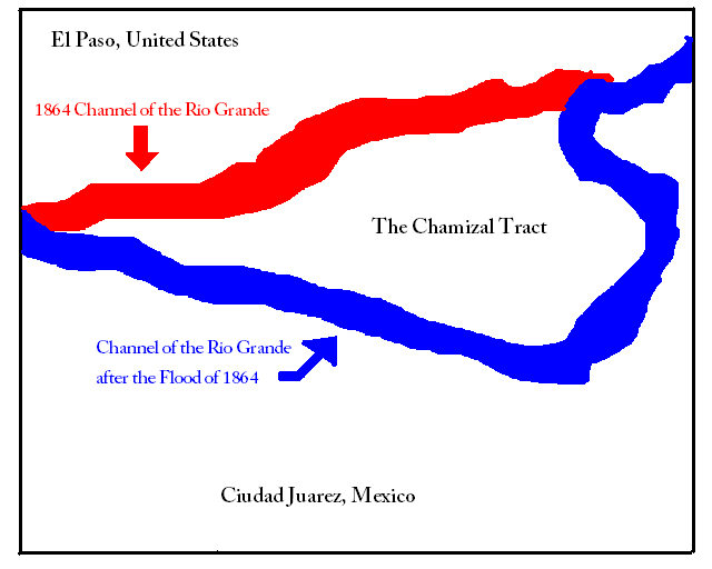 Chamizal was established to commemorate the peaceful resolution to a long-standing border dispute between the United States and Mexico. After the Mexican-American War, the Treaty of Guadalupe-Hidalgo in 1848 established the Rio Grande River as the border between Texas and Mexico, but divided the community of El Paso Del Norte into El Paso (U.S) and Ciudad Juarez (Mexico). Because of flooding each spring, the Rio Grande eventually changed its course and moved further south. Particularly heavy flooding in 1864 and again in 1897 caused the Chamizal tract of land to "switch" sides.
 Following the construction of an artificial cut to control flooding in 1899, Cordova Island became a Mexican peninsula surrounded not by the Rio Grande, but instead by the United States. Lacking a definitive international border, Prohibition-era booze, drug trafficking, and illegal immigration were problematic here during the early 20th century.
 |
| View of the Bridge of the Americas from the grounds of the memorial |
 |
| Historic boundary marker and the cultural center |
 |
| Still earning Junior Ranger badges! |
Then it was time for an early lunch from the regional burger chain Whataburger (more about that later) and a 120-mile drive east to Guadalupe Mountains National Park.


 |
| Manzanita Spring |
 |
| "Right is WRONG!" |
But we quickly found our way back and continued on (and up) towards Smith Spring.
 |
| Abandon all hope, ye who enter here! |
 |
| Note how the vegetation has changed from scrub brush to trees by Smith Spring |

We finished the hike with just enough time to go back to the visitor center before it closed and collect our swag.

We are staying in Carlsbad, NM at the Best Western Stevens Inn for the next two nights. Because of the demand for oil field workers in this area, rates for hotel rooms are quite high, although they are about 20% lower than what we would have paid last year. An added benefit of staying where there are a lot of long-term guests is that were enough washers/dryers to get all of our laundry done in one shot! Yay!

We are staying in Carlsbad, NM at the Best Western Stevens Inn for the next two nights. Because of the demand for oil field workers in this area, rates for hotel rooms are quite high, although they are about 20% lower than what we would have paid last year. An added benefit of staying where there are a lot of long-term guests is that were enough washers/dryers to get all of our laundry done in one shot! Yay!
Carlsbad Caverns tomorrow...
No comments:
Post a Comment